• Skip to primary navigation
  • Skip to main content
  • Skip to primary sidebar
  • Skip to footer

Centre for Artificial Intelligence and Cybersecurity – AIRI

  • Home
  • About Us
    • Vision, Mission and Goals
    • Center Activities
    • Center Faculty
    • Steering Committee
    • Press
  • Research
    • Scientific Projects
    • Research Papers
  • Laboratories
    • Machine Learning
    • Natural Speech & Language Processing
    • Blockchain Technology
    • Information Processing & Pattern Recognition
    • AI in Medicine
    • Data Mining
    • Computer Vision
    • Human-Computer Interaction
    • Maritime Cybersecurity
    • Autonomous Navigation
    • AI in Mechatronics
    • AI in Education
    • Hybrid Computational Methods
    • Drug Design
    • Legal Aspects of AI
    • Ethically Aligned AI
    • Cultural Complexity
  • Collaboration
    • Industry Collaboration
    • Industry Projects
    • International Collaboration
  • News
  • Contact

Analysis of Primary Position Validation in ECDIS System

14.06.2019

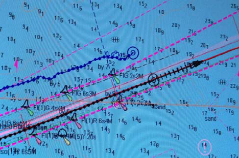
The mandatory ECDIS transitional period has ended just recently. The technology matured and the progress towards the ECDIS as a primary means of navigation has continued. Safe and effective navigation mostly relies on accurate and valid positioning despite the system’s technological advancement. In general, the frequency of plotting and monitoring of ship’s position depends on two factors: employed navigational means and navigational areas. When using paper charts for primary means of navigation, position plotting frequency usually ranges from several minutes to one hour according to the Safety Management System (SMS) or other relevant requirements. In the case of ECDIS navigation, primary position is continuously displayed, mostly by the employment of satellite positioning means, with the possibility of secondary positioning display, depending on the source. Validation by position cross-checking is therefore essential for preventing overreliance on ECDIS primary position. In different navigational stages the navigator can use well known methods from celestial, coastal or electronic navigation. In the proposed paper, accuracy and complexity of positioning methods commonly used by the navigators are evaluated. The obtained results are correlated to primary positioning validation in ECDIS and compared with maritime user requirements, recommendations and respective resolutions. The research is accompanied with survey results on position checking methods conducted among the navigators. Results revealed that most of the navigators validate primary position, however there are misinterpretations between position validation, position fixing and secondary position source. Among stated, other overall and specific findings are presented and discussed. Future research directions are proposed in terms of the necessity of position checking, availability of positioning sources and further development of the system

Authors:
Davor Šakan, Srđan Žuškin, David Brčić, Sanjin Valčić
Journal:
Advances in Marine Navigation and Safety of Sea Transportation
Publishing date:
14.06.2019

Primary Sidebar

Latest Projects

Machine Learning for Knowledge Transfer in Medical Radiology

Estimating River Discharges in Highly Stratified Estuaries

Multilayer Framework for the Information Spreading Characterization in Social Media during the COVID-19 Crisis (InfoCoV)

European Network for assuring food integrity using non-destructive spectral sensors

National Competence Centres in the Framework of EuroHPC (EUROCC)

Latest Research Papers

Rule-Based EEG Classifier Utilizing Local Entropy of Time–Frequency Distributions

Rethinking Effects of Innovation in Competition In The Era of New Digital Technologies

A Comparison of Approaches for Measuring the Semantic Similarity of Short Texts Based on Word Embeddings

Indoor Localization Based on Infrared Angle of Arrival Sensor Network

Gravitational-Wave Burst Signals Denoising Based on the Adaptive Modification of Intersection of Confidence Intervals Rule

Latest News

U Rijeci radi Centar za umjetnu inteligenciju, već su u prvoj godini rada povukli šest milijuna u 14 projekata

UNIRI Excellence Awards in Science

Talk on conference “Exploring Digital Legal Landscapes”

ICAIH 2020 conference presentation

International conference “Exploring Digital Legal Landscapes” – 11th of December, 2020

We provide the expertise for solving real world problems using AI

If your company wants to implement artificial intelligence in your products or services, or increase your level of cybersecurity, our multidisciplinary team of scientists is your ideal partner.

Contact us

Footer

Center for Artificial Intelligence and Cybersecurity
  • jlerga@airi.uniri.hr
  • +385 51 406 500

University of Rijeka

University of Rijeka

About the Center

  • About Us
  • News
  • Privacy Policy
  • Contact

Center Activities

  • Laboratories
  • Scientific Projects
  • Industry Projects
  • Research Papers
  • Industry Collaboration
  • International Collaboration

Footer bottom left

© 2020 Center for Artificial Intelligence and Cybersecurity, all rights reserved.

Designed & developed by Nela Dunato Art & Design